INTRODUCTION
First, for reference, download a copy of this map - http://www.jreast.co.jp/e/info/map_a4ol.pdf
TIP - I like to download it and keep it on my phone/tablet so I can access it even if I don't have internet access via wifi or cellular. More about mobile/wifi access later.
UPDATE - as of March 2020, there’s a new stop on the Yamanote line: Takanawa Gateway! It’s nestled right between Shinagawa and Tamachi and you’ll see it in the updated screenshot below.
JR Yamanote Line - Tokyo
Okay, I know the map looks crazy, but let's start with the green ring in the center. That's the Yamanote Line and it's just a big circle that goes around Tokyo and includes most of the major areas like Tokyo, Shibuya, and Shinjuku. It’s a great place to start learning how to get around the rails. The good news is that even if you get on the wrong platform, it's just a matter of time before you get back to where you need to get off!
Hopefully your hotel is near one of the main stations! Even if it isn’t, a few trips to/from the station will have you getting used to it.
ENTRANCES AND EXITS
Again, I feel like the sites that tell you to go from point A to point B are really missing a key detail: The importance of knowing where to enter and exit the stations. This is of massive importance in the mega-stations like Tokyo, Shinjuku, and Shibuya.
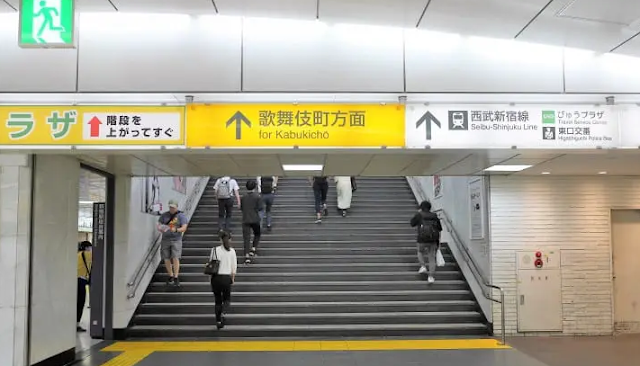
Depending on the train station you go to, it'll be a simple set of “North Exit” and “South Exit” signs or it could be crazy with multiple entrances, exits, and sub-exits! I can’t overstate this: It's extremely important to pay attention to entrances and exits. They're typically labeled with a large, yellow sign and direction like “South Exit” or “Main Exit” along with streets or major landmarks that are outside of that exit. For example:
for Shinjuku Gyoen National Garden
for Kabukicho
They may be labeled with a letter/number combination like "A5" or “B3”. This becomes important when you arrive at a destination and want to exit the station on the correct side of the street (closest to where you want to go). It's also important (obviously) when you return to the hotel and want to exit the station closest to your hotel. Typically there's a map before you go through the turnstiles and one when you exit - so before you leave your destination station, you can scope out which exit is best for you.
In this example from Shibuya Station (thanks Google maps!), you can see the “main” Hachiko exit (arguably the most popular) and other smaller exits labeled with “A” and a number. If you wanted to get to “Magnet by Shibuya” in the upper right hand corner, your best bet would be to get out right at exit A12. This can be super-helpful when it’s raining or hot/humid outside! As you can imagine, if you just exited randomly (exit A5-1, for example), you’d be far from your destination and may even have to enter/exit the station again to get there.
Plan ahead and use Google or even the JR official site to find maps for your station(s).
JR East - station maps (English)
https://www.jreast.co.jp/e/stations/
Some of these stations (Tokyo, Shibuya, Shinjuku) are massive underground cities and if you get your exit/entrance wrong, at best-case you'll be walking around for a long time to get where you want to go - worst-case you could be disoriented/lost for awhile! Remember to look for maps inside the station since they can show you an overhead view of your position and the different nearby exits. NOTE - many of the maps are oriented from your current perspective, so North may not be “up” - pay attention to that when reading the map.
SWIPING YOUR CARD / FINDING YOUR PLATFORM
You did get a Suica to pay for the train, right?
You’ll easily see the turnstiles/gates that you need to pass through to access the train platforms (people will be pouring in and out!). Look for the ones with the green arrow (or simply follow the other traffic) since many of these gates can be changed from entrance/exit during peak times. Once you're at the gate, simply touch your IC card to the turnstile/gate (many Japanese leave them in their wallet/phone case since it still works), you’ll hear a sharp beep and then you can enter find your platform.
More details about paying, checking your balance, and using the card for other things on the main IC card page.
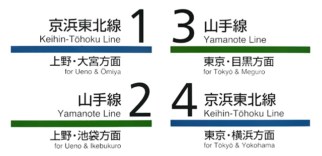
Everything's color-coded and numbered, so for the Yamanote line, look for the green solid line. From there, you'll see the Line name and a track/platform number like "2" or "3" in the case of this example. You'll see that under each colored line, there's a list of a few destinations - that will help you determine which way you want to go. For example, if you're at the Akihabara station and you want to go to Tokyo, you would hop on the line that lists Tokyo and Meguro. Your destination won't always be explicitly listed so knowing what stops are in that direction will help you if you’re heading the right way or not.
Look at a map of the Yamanote line and find Akihabara (it’s near Tokyo). Can you tell which of the Yamanote Line tracks you’d want to be on to go to Shinjuku? Shibuya?
SOME KEY DESTINATIONS ALONG THE YAMANOTE LINE
Shibuya - home of shops, restaurants, bars, etc. Tons of stuff to see and do here. (for the busy intersection - look for the Hachiko exit). FYI - Hachiko was the name of a dog that famously waited at the station for his master to come back, though his master was killed, he continued to wait for years - there's a statue there =)
Shinjuku - one of the largest and busiest stations - tons of shopping and kabukicho ("red light district") though certainly not as "seedy" as it sounds - it's been cleaned up a lot lately
Ebisu - this is a nice laid back area that I'll provide more detail for. I totally suggest you hang out here for some food/drink!
Harajuku - famous for it's fashion street and "gothic lolitas" posing around the station; you must go to Meiji Jingu shrine - what an oasis in the middle of Tokyo!
Akihabara - if you have time and interest - this is their "electric town" which is full of shops related to electronics, toys, manga, anime, maid cafes, etc.
Tokyo - giant station - you probably don't need to exit here for anything unless you want to see the Imperial Palace and some museums - this really drops you into the business/downtown district.
Ikebukuro - is now taking over as a Pokemon/Anime destination! There's a large Pokemon center and a huge Animate is opening soon!
BEYOND THE YAMANOTE LINE
After becoming comfortable with the Yamanote line, you can then learn about the other lines and destinations that you want to go to. For example, Yokohama is nice since there's a Chinatown, parks, and it's more "wide open" than Tokyo. If you study the JR map, you can see that you can change trains at Shinagawa (or other spots) and take another line down to the Yokohama area (including Sakuragi-cho for more shopping/eating). When you change lines, you can typically do that within the station (don't swipe out/in) except for some exceptions. The Suica will charge your card based on where you exit.
Odaiba - head out there for more shopping with giant robots (Gundam Unicorn at DiverCity by the food court) and the "robot" monorail - Yurikamome (transfer at Shinbashi on the Yamanote line)
https://www.yurikamome.co.jp/en/
Next time, we'll talk about the Subway/Metro and the destinations off of there! The Subway is a totally different set of lines that criss-crosses Tokyo, but luckily the Suica covers both JR and all the subway providers. With the JR and Subway/Metro - you can practically get anywhere!


